
For much of its history, Germany was not a single nation but a collection of independent states and principalities, each with its own rulers, economies, and industries. Many of these territories drew their wealth and influence from mining, particularly the discovery of silver in Saxony’s Erzgebirge, translated into English as ‘Ore Mountains’, during the Middle Ages. Silver transformed the region’s fortunes, financed castles and cathedrals, and gave rise to the German thaler – the coin that later inspired the modern dollar.
These early mining states fostered a deep tradition of scientific study and engineering, culminating in the founding of the Freiberg Mining Academy in 1765, one of the first institutions specifically devoted to geology and mineralogy. Over time, Germany’s fragmented but resource-rich landscape produced an extraordinary variety of minerals, from silver sulfosalts and iron ores to pegmatite phosphates and volcanic zeolites.
Due to centuries of intensive mining and changes in the economic landscape, most of Germany’s mines are now long closed, making the majority of available specimens historic in origin. Today, collecting fresh material is difficult because access to underground workings is usually impossible. Any new finds usually come from old mine dumps, surface exposures, or the limited reworking of shallow deposits.
The following list of localities represents the most historic and mineralogically significant regions of Germany. Each reflects a unique combination of geology, history, and craftsmanship, telling the story of a nation built on the treasures of its mountains.
For a Map of Mineral Locations in Germany click HERE
|
Freiberg District (Himmelfahrt Mine), Mittelsachsen, Saxony
Stibnite on Calcite - Image Credit: Dguendel, CC BY 4.0 Discovered in the late 12th century, the deposits around Freiberg became the heart of European silver mining and a lasting symbol of Saxony’s mineral wealth. Hydrothermal veins cutting local gneiss contained rich ores of silver, lead, zinc, and arsenic minerals, along with fine crystallisations of calcite and quartz. Weathering later produced a wealth of attractive secondary species prized by collectors. Legend says the deposit was found when traders, repairing a damaged cart with local stones, later discovered them to be silver ore – sparking the great 'Berggeschrey' or 'silver rush' in the Erzgebirge. By the 19th century, over 100 km of workings extended to a depth of 230 metres before eventually consolidating into the vast Himmelfahrt Mine, which remained active until the 1960s. Freiberg’s silver wealth built the region’s palaces, churches, and guilds, and it inspired the founding of Europe’s first mining academy, making the town synonymous with mining science. |
|
Schneeberg District, Erzgebirgskreis, Saxony
Smaltite - Image Credit: Didier Descouens , CC BY-SA 3.0 About 60 kilometres southwest of Freiberg, the Schneeberg district rose to prominence in the 15th century for its rich silver and cobalt ores, and later for uranium minerals used in early radiological research. The Variscan schists and gneisses of the area host numerous veins carrying silver, cobalt, nickel, tin, bismuth, and uranium minerals. The area is more spread out than Freiberg and was therefore worked by at least 40 separate mines. Weathering of the primary ores produced nearly 170 mineral species, twenty-five first described here, making Schneeberg a classic locality for collectors. The uranium mineralisation is concentrated towards the south of the region worked mainly by the Daniel, Adam Heber, Siebenschlehen and Wolfgangmaßen mines. Their vividly coloured uranium and cobalt ores were initially used as pigments in Germany’s glass and porcelain industries and later in atomic research. |
|
Annaberg-Buchholz District, Erzgebirgskreis, Saxony
Rabbittite on Gypsum - Image Credit: Joy Desor, BY-SA 3.0 DE Discovered in 1496, Annaberg–Buchholz became another of Saxony’s rich silver-mining centres during the great 'Berggeschrey' or 'silver rush'. Veins cutting through granite and schist yielded native silver, bismuth, siderite, fluorite, and primary copper and nickel ores that later produced many secondary minerals, including annabergite, first discovered and described from here. The mineral species count at present exceeds 150 individual species. Mining was extensive, with at least fifty recorded operations, including the Bäuerin, Markus Röhling, and St. Briccius mines. Though silver mining declined sharply by the late 19th century, some of the area’s mines were later explored and worked for uranium. Around 40 different uranium minerals have been identified. The prosperity generated by silver mining financed the area’s distinctive Baroque architecture, securing Annaberg-Buchholz’s place among Europe’s classic historic mining districts. |
|
Ehrenfriedersdorf District, Erzgebirgskreis, Saxony
Argentopyrite and Proustite - Image Credit: Leon Hupperichs, CC BY-SA 3.0 Unlike most of the other mining regions in Saxony, Ehrenfriedersdorf was initially mined for tin, although it later became important for silver extraction as well. The deposit was discovered in the 13th century and consists of greisen vein-type tin-tungsten deposits containing a wide variety of associated minerals, including cobalt and arsenic ores. The dominant mine in the area was the Sauberg Mine, which produced cassiterite, wolframite, topaz, and beryl, often accompanied by purple and green fluorite. The area’s mineralisation has been studied extensively and has become a classic locality for studying greisen-type mineralisations. Metal ores, beryl, topaz and fluorite specimens from the Sauberg Mine remain sought after for their fine crystal form and historical significance. |
|
Schneeberg-Schlema-Alberoda-Zobes-Bergen, Erzgebirgskreis, Saxony
Tobernite - Image Credit: Raimond Spekking, CC BY-SA 4.0 Mining in the region began in the 15th century for silver, cobalt, nickel, and bismuth, but the area later gained fame for its radioactive springs, which led to a radium spa established in 1914. After World War II, Soviet geologists explored the district for the source of radioactivity, and from 1946 to 1990, the Soviet-owned Wismut company made Schlema–Alberoda one of the world’s top uranium producers, ranking East Germany fourth globally. The Alberoda and Niederschlema mines, reaching nearly two kilometres deep, were the deepest mines of any type in Europe, extracting uraninite, coffinite, fluorite, and baryte from hydrothermal veins in gneiss. Minor tin–tungsten and lead–zinc mineralisation added to a total of more than 100 recorded mineral species. Mining ceased after German reunification, followed by major reclamation work. Schlema’s history captures the intersection of geology, health, and Cold War geopolitics that defined much of 20th-century European mining. |
|
Marienberg, Erzgebirgskreis, Saxony
Marienberg Erzgebirge - Image Credit: Public Domain, Founded in 1521 by Duke Henry the Pious, Marienberg was a purpose-built town on a plateau in the Erzgebirge to serve the area’s silver deposits discovered in 1519. The town’s grid layout was one of the first Renaissance-style planned mining towns north of the Alps. Mining activity involved around 40 mines, some working until the late 1950s. The veins cut metamorphic rocks and granitic intrusions, producing silver, tin, copper and later uranium and fluorite. After its silver peak in the late 16th century, the district gradually turned to tin and copper, then later diversified further. Some notable operations in the district include Vater Abraham, St Johannes and Rudolph mines. The richness of the mineralisation gave rise to at least 150 different minerals, including some rare bismuth, cobalt and silver species, as well as being the type location for lautite, named after the nearby village Lauta. Today Marienberg’s historic centre and its mining landscapes, including Lauta, are part of the UNESCO World Heritage site recognising the region’s geological and cultural significance. |
|
St Andreasberg, Braunlage, Harz Mountians, Goslar District, Lower Saxony
Native Arsenic - Image Credit: Ra'ike, CC BY-SA 3.0 Mining at St. Andreasberg began in the late 15th century, and by the 16th it had become another of Germany’s great silver districts. The famous Grube Samson mine reached 840 meters deep and operated until 1910. Steep hydrothermal veins in Devonian limestone and schist yielded native silver, galena, sphalerite, and fine calcite and silver-sulfide specimens. More than 200 minerals are known from the district, including eight type locality species, including harmotome, samsonite, albite, and arsenolite. The region’s ingenious water-powered drainage and hoisting system, known as the Upper Harz Water Regale, enabled deep mining centuries ahead of its time. Today, the area forms part of the UNESCO-listed Harz mining landscape, with Grube Samson preserved as a museum showcasing this remarkable blend of geology, innovation, and mining history. |
|
Clausthal–Zellerfeld, Harz Mountains, Goslar District, Lower Saxony
Tetrahedrite and Pyrite - Image Credit: Leon Hupperichs , CC BY-SA 3.0 Mining at Clausthal–Zellerfeld began in the 12th century and by the 16th had become one of Europe’s leading silver- and lead-producing centres. The region’s hydrothermal veins, known as the Burgstätter Gangzug, cut through Paleozoic slates and limestones, carrying silver, galena, sphalerite, chalcopyrite, siderite, and quartz. Major workings such as the Caroline, Dorothea, and Kaiser Wilhelm II mines reached depths over 600 m before operations ceased in the 1930s as ores became exhausted. Clausthal is also famed for engineering innovation – notably Wilhelm Albert’s 1834 invention of the wire rope, a major advance in mine safety and hoisting, which replaced chains. The district’s technical legacy led to the founding of the Clausthal Mining Academy, still a leading institution in mining science. Today, Clausthal–Zellerfeld and its neighbouring districts of Altenau, Bad Grund, Wildemann, and Hahnenklee form part of the UNESCO-listed Upper Harz mining landscape, with the local museum preserving its industrial heritage and outstanding mineral history. |
|
Ramsbeck, Sauerland, North Rhine–Westphalia
Baryte - Image Credit: Malchen53, CC BY-SA 3.0 Mining in Ramsbeck originated in the 14th century, though significant industrial-scale operations only emerged in the mid-19th century when lead and zinc extraction expanded rapidly under the government of the newly formed German republic. The ore occurs in NE-SW trending quartz-baryte veins within Devonian schists and quartzites, with principal workings at the Bastenberg and Dörnberg zones. Noteworthy mineral specimens from Ramsbeck include anglesite, boulangerite, smithsonite, and the type-locality mineral ramsbeckite. Mining ceased in 1975, and the site has been repurposed as the Sauerländer Besucherbergwerk – a visitor mine and museum that takes guests 300 m underground and traces the region’s mining heritage on an 11 km overground Mining Trail. |
|
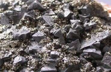
Siegerland District, Neunkirchen, Arnsberg, North Rhine-Westphalia
Linneite and Chalcopyrite - Image Credit: Joachim Esche, CC BY-SA 3.0 DE The Siegerland region boasts a mining heritage stretching back more than 2,500 years, beginning with surface-extracted iron ore in Celtic times and evolving into one of Central Europe’s major iron- and metalliferous-ore districts. These ores fuelled iron and steel production and contributed to the rise of the Ruhr industrial belt. Geologically, the region lies within the Rhenish Massif and is characterised by iron-rich veins and nodular deposits in slate and greywacke, accompanied by lead, zinc and copper ores. The region’s deep mines, which include the 1,300-metre-deep Pfannenberger Einigkeit and Eisenzecher Zug operations, illustrate the scale of industrial mining here. Hematite, goethite, and siderite crystals from Siegerland are highly prized for their beauty and historical significance. The last operational mines closed by 1965, but the legacy persists through tourist mines, notably the Reinhold‑Forster‑Erbstollen. |
|
Idar–Oberstein, Birkenfeld, Rhineland
Calcite on Quartz - Image Credit: Robert M. Lavinsky, CC BY-SA 3.0 The town of Idar–Oberstein has been a pivotal centre for gemstones and mineral processing for over five centuries. Local quarries and mines such as those at Steinkaulenberg, Schönlautenbach and Göttschieder Heide produce striking agates, jasper, rock crystal and amethyst from volcanic and basaltic flows in the Hunsrück region. These were worked by local artisans into beads, intaglios and jewellery. Situated on the banks of the Nahe River, the town used waterpower for grinding and polishing machines throughout the 18th and 19th centuries. Even after local sources declined, cutters imported agates from Brazil, establishing Idar–Oberstein as a global center of gemstone artistry. Today, the area continues to produce occasional world-class specimens of agate, chalcedony, rock crystal, and jasper, as well as attractive zeolites like harmotome and silicates like pale-yellow prehnite. |
|
Eifel Volcanic Region, Rhineland
Hayune - Image Credit: Lucien Cluzaud, Public Domain The Volcanic Eifel region in the west of Germany is a raised highland shaped by more than 350 eruption sites, maars (volcanic crater lakes), lava flows and mineral springs, now preserved as a UNESCO Geopark. The alkaline, silica-undersaturated basanite and nephelinite magmas that once erupted here have produced a range of unusually diverse and rare minerals that include gem-quality blue sapphires. Localities near Mendig, Ettringen and Ochtendung are especially prized by mineral collectors for their feldspathoids, which include hauyne, nosean and sodalite, and also for sanidine and augite crystals from local basalt quarries. Historically, the region’s rich volcanic sediments and springs also attracted the development of mineral water industries due to the waters’ perceived health benefits. The Laacher See volcano and Wingertsbergwand outcrop provide exceptional sites for studying volcanic mineral formation and eruption history. |
|
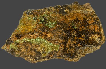
Hagendorf Pegmatites, Waidhaus, Neustadt an der Waldnaab, Bavaria
Strengite - Image Credit: Christian Rewitzer, CC BY-SA 3.0 Located in the Oberpfalz region of northeastern Bavaria near Waidhaus, the Hagendorf North and South pegmatites rank among the world’s most important mineral-specimen localities. Mining began around 1894 for ceramic-grade feldspar and later for lithium-rich triphylite - operations which continued until 1984. Geologically, they are large zoned granitic pegmatites that yielded a remarkable suite of primary and secondary phosphate minerals. To date, more than 220 valid mineral species have been identified here, and the area is the type locality for 34 minerals, most of which are rare phosphates that include steinmetzite, wildenauerite, nordgauite, and zincoberaunite. Although the original quarry sites are now flooded and protected as nature habitats, the extensive historic collections made prior to closure ensure that Hilgendorf’s mineral legacy remains preserved. |
|
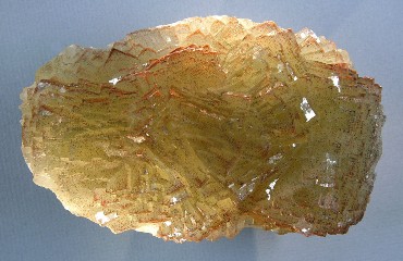
Wölsendorf–Falkenstein Fluorite District, Upper Palatinate, Bavaria
Fluorite - Image Credit: Hannes Grobe, CC BY-SA 2.5 Mining at Wölsendorf dates back to the 15th century, first for lead and silver but later, in the 19th and 20th centuries, for fluorite used in the steel industry. The district’s quartz–baryte–fluorite veins cut the crystalline rocks of the Bavarian Forest and Bohemian Massif, worked mainly by the Marienschacht and Johannesschacht mines. Wölsendorf is the type locality for the rare uranium–lead mineral wölsendorfite, but it is best known for its vivid violet, green, and yellow fluorite crystals, often beautifully zoned and among Germany’s most striking specimens. Mining ended in the late 1980s, yet the district remains celebrated for its colourful fluorite, rich mineral diversity, and central role in Germany’s fluorite mining history. |
|
Black Forest (Schwarzwald), (Clara Mine), Baden-Württemberg
Goudeyite - Image Credit: Henk Smeets, CC BY 4.0 The Black Forest has been mined for over 700 years for silver, lead, zinc, fluorite, and barite from hydrothermal veins cutting gneiss and granite. Early workings such as the Silbergründle Pit near Seebach date to the 12th century, with later mines including Käfersteige and Segen Gottes. The region’s most famous site, however, the Clara Mine at Oberwolfach, holds legendary status among collectors as Germany’s most prolific and scientifically significant mineral locality. In continuous operation since the 18th century, Clara has produced nearly 500 mineral species, including numerous type-locality and rare secondary minerals formed through at least four distinct mineralising stages. Its fluorite–baryte veins yield superbly crystallised and vividly coloured specimens, making Clara a world-renowned benchmark for both collectors and researchers and the last active link to the Black Forest’s once-flourishing mining tradition. |


From the valuable silver veins of Saxony to the fluorite mines of Bavaria and the volcanic treasures of the Eifel, Germany’s mineral localities reflect centuries of human ingenuity and natural beauty. Silver, the foundation of early prosperity, not only built cities and economies but also inspired the development of mining science itself. Today, the minerals of Germany remain a testament to both geological wonder and the enduring legacy of the miners, scientists, and collectors who revealed them to the world.